
Robot Inspection Solution for Scenic Areas and Wetland Parks
Robot Inspection Solution for Scenic Areas and Wetland Parks
Against the policy backdrop of embodied intelligence being incorporated into the cultivation of future industries, the shortcomings of traditional manual patrol models in ecological and cultural tourism scenarios 一 such as forestry management and protection, nature reserves, cultural tourism scenic areas, and forest parks 一 have become increasingly prominent. Forest areas and reserves are vast with complex terrain, manual patrols have limited coverage and numerous blind spots, and hazards such as fires and illegal logging are detected with delay; forest rangers face high operational risks and heavy labor cost pressures. In scenic areas and botanical gardens during peak visitor periods, manual control struggles to cope with instantaneous crowds, inspections of cultural relics and infrastructure suffer from omissions, and pressure on visitor guidance and order maintenance is pronounced. Meanwhile, traditional inspections mostly use paper records, making it difficult to aggregate data in real time and unable to support refined ecological assessment and management decision-making. The industry is accelerating the unmanned replacement of high-risk field patrols, relying on intelligent equipment such as quadruped robot dogs to build a human defense + technical defense system, achieving all-domain routine perception and enhancing ecological protection and scenic area safety management capabilities.
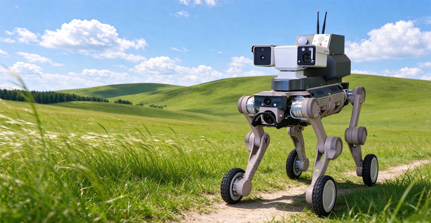
Overall Project Overview
Core Objectives
Implement the requirements of the Forest Chief System and intelligent fire prevention construction, and build an air-ground-human-machine integrated intelligent forest patrol system to achieve all-domain coverage and efficient management and control.
Solution
Targeting areas difficult for people and vehicles to traverse, such as steep slopes, ravines, and dense forests, the AgiBot Kuituo D1 Max bionic quadruped robot is introduced to break through terrain limitations and enable flexible and mobile inspection.
Core Tasks
Replace and supplement forest rangers in carrying out routine patrols, early fire warning, precise fire scene reconnaissance, and hazard inspection, building a solid first line of defense for forest safety.
Project Value
Compensate for the blind spots of fixed surveillance and drones, achieve all-weather, close-range, refined monitoring of key areas, and comprehensively enhance the digital combat effectiveness of forest fire prevention.

AgiBot Kuituo D1 Max 一 An Intelligent Pioneer for All-Terrain Forest Patrol
Equipped with a multi-sensor fusion perception system, it adapts to complex terrains such as mountains and dense forests, providing hardcore technological support for forest fire prevention.
Overall Solution Introduction
The solution is built around the coordinated construction of five core functional modules. Driven by intelligent technologies, it deeply integrates the robot dogs high mobility and adaptability to complex environments with AI visual recognition and multi-sensor fusion technologies, comprehensively covering the key needs of ecological protection and scenic area management. It builds a full-process, intelligent ecological governance closed-loop system, forming a complete governance loop of integrated perception, monitoring, early warning, handling, and inspection.
All-Domain Autonomous Ecological Inspection
Through autonomous planning of inspection routes, it achieves full-coverage, dead-corner-free routine patrols, effectively addressing the shortcomings of traditional inspection in spatial breadth and temporal continuity.
Real-Time Ecological Environment Monitoring
Equipped with multiple types of high-precision sensors, it performs precise perception and quantitative analysis of key environmental elements such as air quality, meteorology, and negative oxygen ion concentration, providing scientific data support for ecological assessment.
Video Surveillance and Intelligent Recognition
As the smart brain of intelligent inspection, the system uses AI algorithms to automatically identify anomalies such as unauthorized personnel intrusion, vegetation pests and diseases, and fire hazards, enabling early discovery and early warning of problems.
Voice Guidance and Audible-Visual Warning
Integrating two-way voice intercom and audible-visual alarm devices, it supports remote broadcasting and guidance from the backend, creating on-site deterrence against violations, enhancing the flexibility and effectiveness of emergency handling, and reducing manual intervention costs.
Special Inspection of Ecological Facilities and Key Areas
Targeting key areas such as ecological monitoring stations, forest fire prevention towers, and habitats of rare animals and plants, it conducts high-frequency, refined special inspections to ensure the integrity of infrastructure and safeguard the security of core ecological resources.
Overall Construction Architecture: Layered Design, Interconnected Communication
Adopting an overall system architecture featuring layered top-bottom structure, interconnected communication, scalability, and integrability to build a stable and efficient security inspection system.
Application Layer:Supervision large screen, mobile terminal, PC terminal, secondary development interfaces
Data Layer:Real-time monitoring data, HD video surveillance, intelligent warning information
Hardware Layer:Quadruped robot dog, dual-spectrum PTZ camera, remote broadcasting module, environmental monitoring sensors, LiDAR, data collection terminal
01. Hardware Layer 一 Multi-dimensional Perception Terminals
The AgiBot Kuituo D1 Max quadruped robot dog, along with dual-spectrum PTZ cameras, environmental monitoring sensors, LiDAR, and other sensors, enabling all-round data collection.
02. Transmission Layer 一 High-speed Data Channel
Relying on 4G/5G wireless communication networks, it establishes a low-latency, high-bandwidth data transmission link, ensuring the secure real-time transmission of collected monitoring data and video streams.
03. Data Layer 一 Intelligent Storage Hub
Centrally storing real-time monitoring data, HD video streams, and LiDAR point cloud data, and archiving intelligent warning information and inspection ledgers, providing the foundation for data analysis.
04. Application Layer 一 Comprehensive Business Terminals
Providing project supervision large screen, PC management backend, and secondary development interfaces, supporting multi-terminal collaborative management and customized business expansion.
Quadruped Robot Dog Hardware Body (AgiBot Kuituo D1 Max)
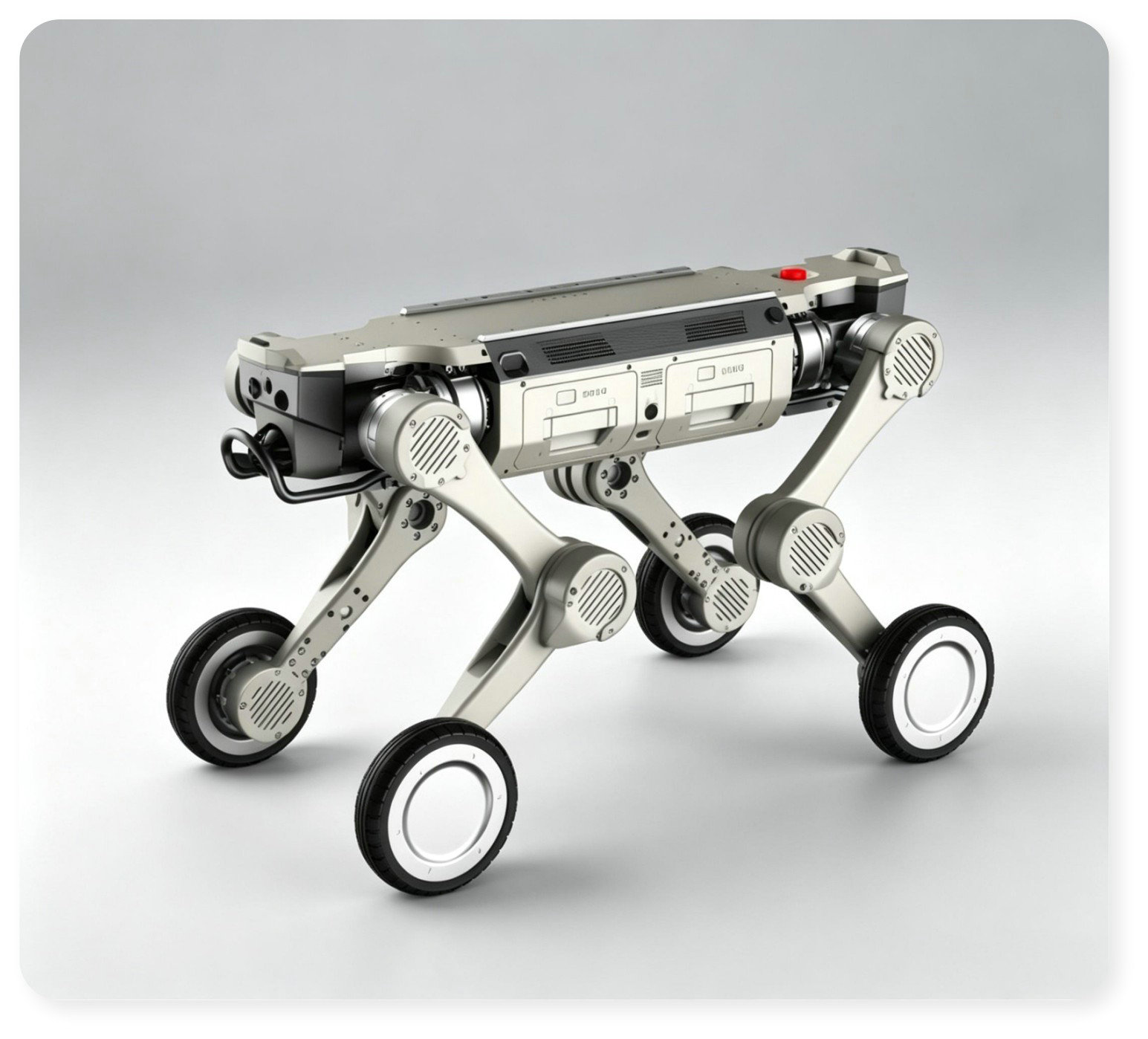
Bionic Gait Adaptability
Bionic quadruped structural design, perfectly adapting to complex unstructured terrains such as gravel, tree roots, shrubbery, and muddy mountains.
Strong Motion Performance
With a maximum climbing angle of ≥40 一 50° and intelligent fall detection and autonomous stand-up capabilities, it ensures stable and reliable field operations.
Wide-Temperature Environmental Adaptability
Operating temperature range of -20°C to +55°C, undaunted by severe cold or scorching heat, meeting the needs of all-weather long-term outdoor operations.
Long-Endurance Assurance
Routine patrol endurance of 2 一 4 hours, with support for fast hot-swappable battery replacement, effectively reducing downtime.
Precise Positioning and Navigation
Integrating GPS + BeiDou dual-mode fusion positioning with LiDAR SLAM technology to achieve autonomous mapping and path planning.
Flexible Operation Modes
Supporting dual modes of preset-route autonomous cruising and manual remote control, with flexible switching according to task requirements.
All-Terrain Adaptability, Adapting to Various Complex Inspection Environments
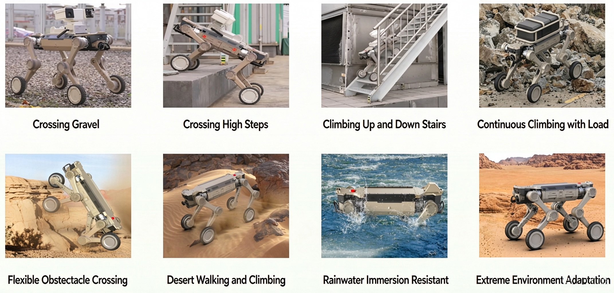
Replaceable Payload (一): Autonomous Inspection Payload
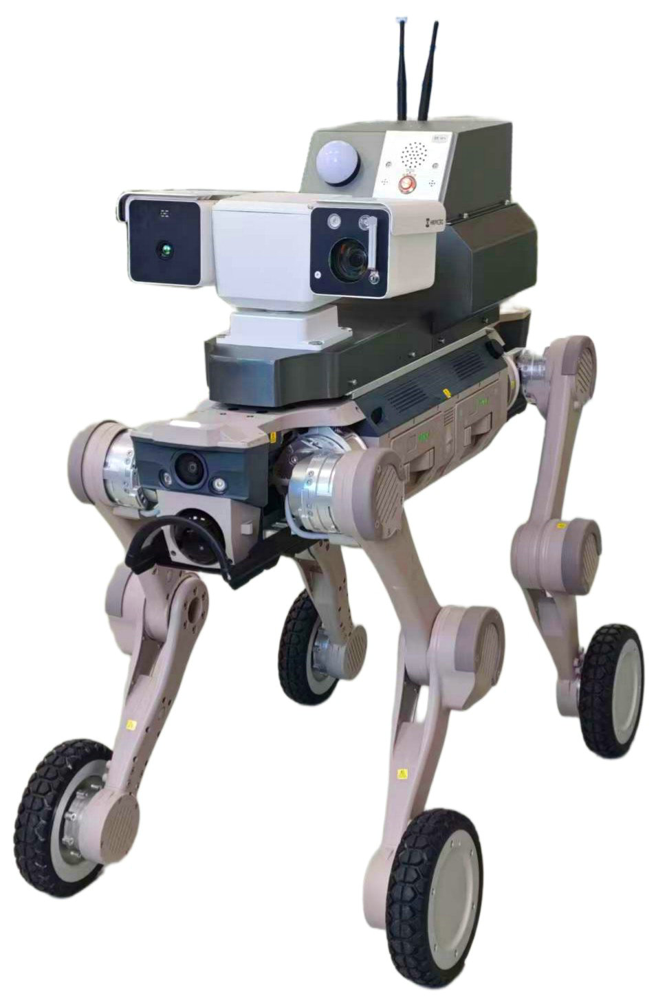
Core Components: Dual-Spectrum PTZ (Visible Light + Infrared Thermal Imaging Dual-Mode Fusion)
HD Visible Light Monitoring
Providing high-definition real-time video footage, clearly restoring the real scene of forest areas, meeting the needs of routine inspection, hazard investigation, and footage recording.
Multi-Dimensional Environmental Perception
Integrating high-precision temperature and humidity sensors and combustible gas sensors, it collects and transmits environmental data in real time, providing key environmental indicator support for forest fire prevention and disaster assessment, and achieving comprehensive perception of environmental conditions.
Infrared Thermal Imaging Detection
Penetrating smoke and darkness, it precisely identifies hidden high-temperature points, hidden fires, and smoldering hazards beneath the forest canopy, achieving all-weather, dead-corner-free fire perception.
AI Intelligent Fire Warning
Equipped with deep learning algorithms, it automatically identifies open flame and smoke characteristics, outputs target coordinates in real time, and triggers multi-level warnings for rapid response.
Remote Audible-Visual Voice Persuasion
Supporting backend remote voice broadcasting and high-decibel audible-visual alarms, it promptly persuades against behaviors such as illegal fire use and personnel intrusion in forest areas, enhancing the flexibility and deterrence of emergency handling and preventing problems before they occur.
Replaceable Payload (二): Mesh Self-Organizing Network Payload
Core Function: Emergency Communication Relay
Building a highly reliable, low-latency emergency communication Mesh self-organizing network, it enables automatic networking and data relay among multiple nodes, breaking through spatial limitations and ensuring communication stability and data transmission continuity in complex disaster environments.
Application Scenario: Communication Assurance in Extreme Environments
Targeting extreme scenarios such as public network interruptions at fire scenes and signal blind zones in mountainous areas, it rapidly deploys self-organizing network nodes, connecting the communication link between frontline rescue and the rear command center, ensuring that rescue instructions are issued and disaster information is fed back without interruption.
Full Process of the Mesh Self-Organizing Network Communication Link
01 Frontline Perception Nodes
Robot dogs equipped with Mesh modules penetrate deep into the core area of the fire scene, collecting key data such as on-site video and temperature and humidity, and transmitting it in real time to relay nodes through the self-organizing network.
02 Relay Networking Hub
The ground base station serves as a signal relay station, aggregating data from multiple robot dog nodes, expanding communication coverage, and achieving interconnection and signal relay among multiple nodes.
03 Global Command Hub
Receiving real-time data fed back from the scene and visually presenting the disaster situation, the command center coordinates and dispatches rescue forces accordingly, issuing precise rescue instructions and decisions.
Replaceable Payload (三): Material Delivery Payload
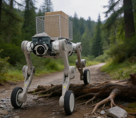
Real-World Application: In mountainous forest environments with complex terrain, the robot dog serves as a companion logistics soldier, providing continuous material supply support for patrol personnel.
Intelligent Companion 一 Core of Material Transport
Equipped with a high-strength customized material delivery compartment and integrated with high-precision intelligent following and path planning modules, it can automatically match the patrol personnels walking speed and route, stably transporting equipment such as water tanks, maintenance tools, and emergency medical kits across complex terrains including mountains and woodlands, achieving efficient person walks, machine follows resupply.
Reducing Burden and Increasing Efficiency 一 Unleashing Human Potential
It effectively replaces manual carrying of heavy equipment, significantly reducing the physical exertion of patrol personnel and lowering fatigue and safety hazards caused by heavy loads. This allows forest rangers to devote themselves fully to core tasks such as fire monitoring, vegetation protection, and facility inspection, significantly expanding the coverage and improving the quality of each patrol.
Replaceable Payload (四): Fire Scene Emergency Payload
01 Core Component: Dual-Mode Precision Fire Suppression System
Equipped with a portable high-pressure water cannon and a dry powder spray dual-module, it supports rapid switching between operating modes. Targeting different types of incipient fires such as solid, liquid, and electrical fires, it achieves efficient extinguishing agent deployment, flexibly adapting to complex and variable fire scene environments.
02 Tactical Value: Safeguarding Lives and Buying Time
Relying on the robot dogs high mobility and remote control capabilities, it rapidly suppresses the initial fire line from a safe distance, effectively blocking the path of fire spread. This not only buys precious golden rescue time for professional firefighting forces to arrive, but also fundamentally avoids exposing firefighters directly to fatal risks such as high temperatures, toxic gases, and building collapse.
Replaceable Payload (五): Understory Terrain Mapping Payload
Equipped with a 3D laser mapping LiDAR and a multi-sensor fusion system, it breaks through vegetation occlusion limitations to conduct high-precision 3D modeling of complex understory terrain, precisely restoring landform details and surface features.
Enhancing Autonomous Navigation Accuracy
Building a high-precision environmental map based on 3D terrain data, it provides the robot dog with real-time terrain perception and path planning capabilities, effectively solving navigation deviations caused by understory occlusion and complex terrain, and significantly improving its motion stability and autonomous operation capability in unstructured environments.
Empowering Forest Fire Prevention and Resource Monitoring
It precisely acquires data on understory combustible material distribution density, terrain slope, and vegetation coverage, providing scientific support for forest fire prevention planning, fire risk assessment, and emergency rescue route design; at the same time, it provides a high-precision geographic information foundation for forestry work such as forest resource surveys and ecological restoration.
Intelligent Patrol Management Software Platform
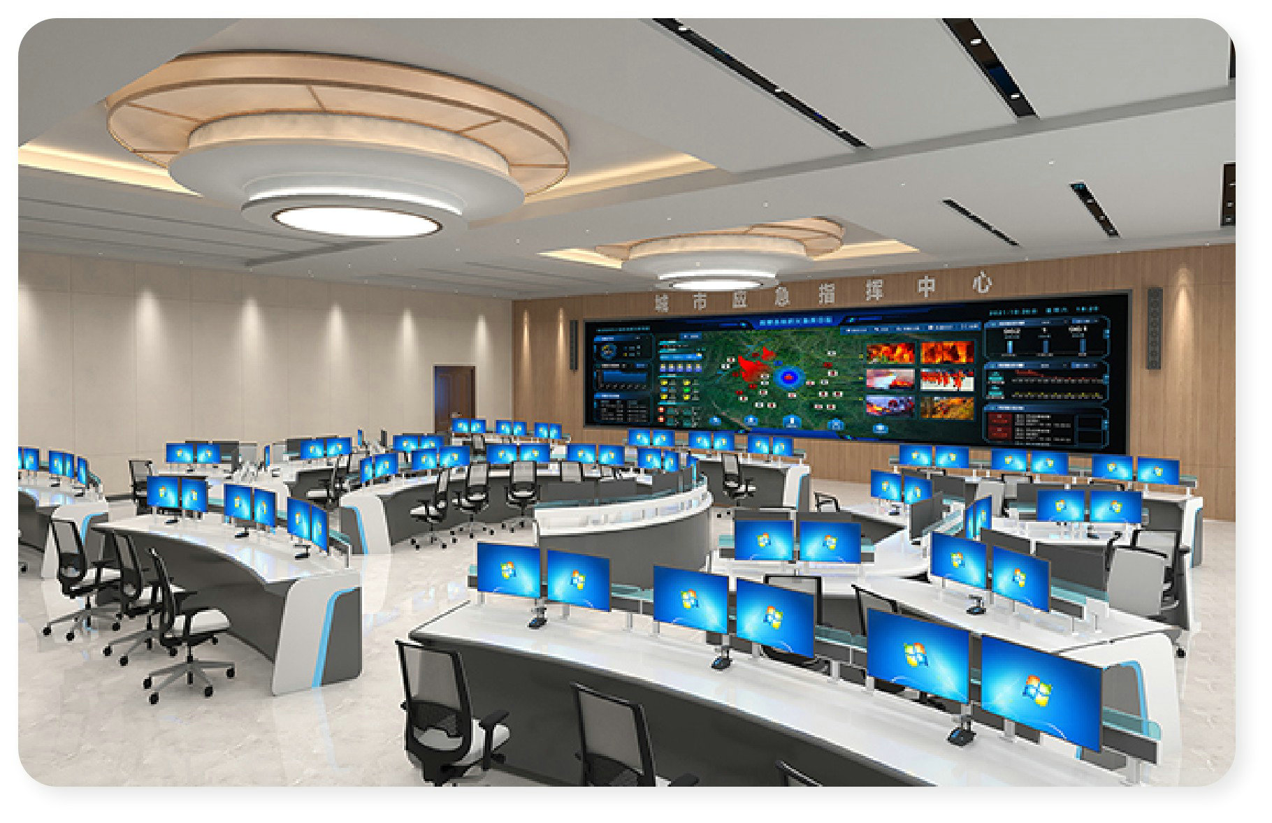
Relying on the visualized command center large screen, it achieves all-round digital monitoring of forest resources, patrol equipment, and fire hazards, building a new smart forest fire prevention paradigm of "viewing the entire area on one screen and managing the whole process through one network, enhancing emergency response efficiency.
One Map
Integrating a GIS engine, it displays the robot dogs position, patrol trajectory, and equipment status in real time, making the all-domain situation clear at a glance.
Intelligent Task Scheduling
Customizing and planning routine patrol routes, supporting scheduled automatic task initiation, and achieving unmanned intelligent inspection scheduling.
Intelligent Alarm Management
Automatic pop-up warnings for anomalies such as smoke and open flames, with real-time push of hazard details to the command terminal for rapid response and handling.
Intelligent Ledger Reports
Automatically generating patrol logs and hazard rectification checklists, with data directly connected to the assessment system, enabling evidence-based Forest Chief System assessments.
Standard Interface Integration
Standardized API design for seamless integration with existing forest fire prevention command platforms and Forest Chief System platforms, breaking down data silos.
Remote Control Terminal
Supporting cross-terminal remote takeover of equipment via PC and tablet, with real-time viewing of footage, enabling remote emergency command and intervention.